


NORTH SMITHFIELD – If you want to know the story of how residents in North Smithfield saved environmentally rich land from development, and established a 42-acre conservation area connected by hiking trails to another 90-acre parcel in Woonsocket, then you may want to pick the year – or even decade – where you would like the tale to start.
Members of the North Smithfield Land Trust celebrated the achievement this week, almost 20 years in the making, with dedication of a sign by the newly mapped trails, just behind Dowling Village.
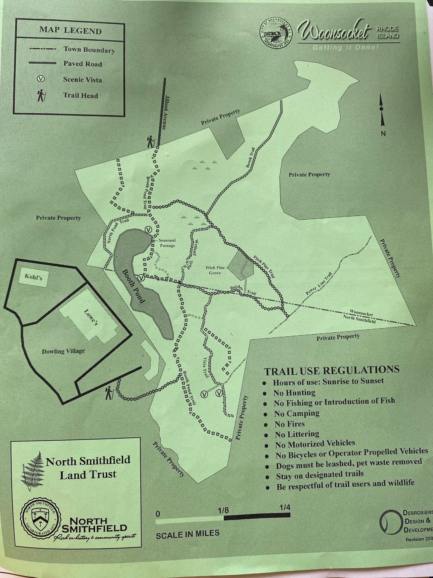
The Booth Pond Conservation Area now features 130 acres of protected natural resources, with scenic hiking trails running through the two towns. Home to various species of wildlife, the forest also serves to protect the local drinking water supply.
This week, a dozen of the people involved recalled the tenacity it took to make it happen.
“This has been a saga, as everyone knows,” said Carol Ayala of the Land Trust.
“It’s been a long time coming,” said Land Trust President Paul Soares, looking out over the path into the open land, situated by the entrance to, “The Club at Dowling Village,” a new apartment complex behind Lowe’s Home Improvement.

On July 1, 2004, the North Smithfield Planning Board approved a master plan for a massive, mixed use project on a forested area of Eddie Dowling Highway. Original plans for what would later become known as Dowling Village envisioned retail stores and condos encompassing an area the size of 30 football fields, including 21 acres of wetlands surrounding Booth Pond. The area is home to 50 species of damselflies and dragonflies including one that’s endangered, and groundwater from the pond flows toward drinking water reservoirs in Woonsocket.
The following year, the firm RAM Investments returned with an even bigger plan for the area – to include a 30-acre “MED Zone,” in Woonsocket.
That’s when conservationists and small business advocates stepped in, forming the Valley Alliance for Smart Growth.
“We won that one,” said Caroly Shumway, former president of the VASG, of the rejected MED Zone. “We cut half of the project out.”
For the next decade, VASG, led by Shumway, would make dozens of appearances before the Town Council, and planning and zoning boards; launch countless petitions and appeals; and even challenge the developer in Superior Court.
The advocacy paid off. The developer reduced the size of the project, cut down some of the retail, and left more than five acres surrounding Booth Pond untouched. And Shumway worked with the Rhode Island Department of Environmental Management to create stormwater regulations that, at the time, were among the most advanced in the state.
The Land Trust, meanwhile, acquired a $400,000 Open Space Grant from the Rhode Island Department of Environmental Management in 2007 to protect 42 acres east of Booth Pond.
But the town would have to provide matching funds to finalize the purchase. North Smithfield voters had approved a $3 million open space bond in 2006, but as a recession plummeted the national economy in 2008, local officials lost their appetite for adding to the town’s debt.
The purchase would stall until 2014, when the land trust finally acquired the property for $925,000, with help from $525,000 from the town’s open space fund. Town Administrator Paul Zwolenski was a member of the council at the time and advocated of behalf of the purchase, which was finally approved. To date, it’s the only land bought with the $3 million bond.
But establishing a the way on to the conservation property would prove a challenge all its own.
It took another six years to map out details of an easement across developer Brian Bucci’s land, finally filed last August.
“Planner Tom Kravitz worked very hard to get a walkable easement,” Zwolenski said.
Soares cleared trails from the conservation land to connect to the access easement.
Some of those involved did not live to see the final product unveiled this week.
There was the late Mary McDonald, former president of the Land Trust, a talented grant writer. Also remembered was the work of the late Albert Brien, a real estate appraiser who made sure the deed for the conservation land included some type of easement.
Shumway moved out of town in 2016 to take a position as chief scientist for the United States Agency for International Development. She recently moved back to Rhode Island and now lives in Cumberland, and this week, she praised members of the Land Trust for finishing the work she started some 17 years ago.
“The tenacity of the people in this Land Trust is to be lauded,” she said.
Others credited this week included Michael Debroisse, head of the Engineering Department in Woonsocket, who coordinated the city’s adoption of the trail regulations so the two properties could function as one, and Steve Desrosiers, an advocate for the project who recorded the trails and created the map and informational text.
Angela Ciociolo designed graphics for the trailhead sign free of charge, and Public Works Director Ray Pendergast and his staff installed the new marker.
“Ray has been working really closely with the Land Trust and the Conservation Commission,” Zwolenski said.
Recently, the town purchased an adjoining 114 acre lot, which, once established, will create a total of more than 240 acres of uninterrupted open space, dubbed an, “unspoiled refuge,” in an otherwise urbanized and highly-developed area.
Hikers can access the area by parking near the apartment complex, and hours are sunrise to sunset. Dogs are allowed, but must be leashed and cleaned up after.
“We want people to use the trails, but we also want them to follow the rules,” said Lisa Harpin, also with the trust.
At the top of the hill on the trails, hikers will find a granite rock marking the border between the two towns with a, “W,” on one side and, “NS,” on the other.
“This is a culmination of a long time, and a lot of work,” said Ruth Pacheco.
Soares noted that the accomplishment of such a long-standing goal is only possible through collaboration.
“We definitely appreciate the cooperation of the administrator and his team,” Soares said. “Under this administration, everyone is a team.”
“Everyone should work together,” Pendergast agreed.

